| RUFA Jan 19th, Pre-Race Event RSVP |
| RUFA YouTube Channel |
| 2024 PreRace Event Live Stream (coming soon) |
Posted by: runuphill | January 14, 2024
Instagram LinkTree Page
Posted in Uncategorized
Posted by: runuphill | July 15, 2017
Millwood 100 – “Official” Page
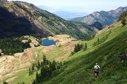
Erik Storheim descending to Lake Blanche during his 2012 run. PC : Greg Norrander
Backround
The idea of Millwood began back in 2010 with simple motives. The Wasatch mountains are home to hundreds of miles of incredible, steep, and rugged trails, yet a small fraction of them are actually used in endurance foot races. The route is compact, taking place completely within the boundaries of Millcreek Canyon and the Cottonwoods (Big and Little), has only 0.5mi of ground that is touched twice, < 1 mi. of road, and hardly any flat terrain. It is easy to set gear caches for solo or minimally support efforts, and similar to objectives such as Nolans 14 and the WURL, you can do it anytime you like. While it is a challenging route, it is not technical. Portions of it feel poorly maintained because, well, they are poorly maintained as a result of minimal traffic. For the most part, however, the route is on nice steep trails.
Posted in Running
Posted by: runuphill | April 16, 2016
Barkley 2016 – Act 4 (the Guide)
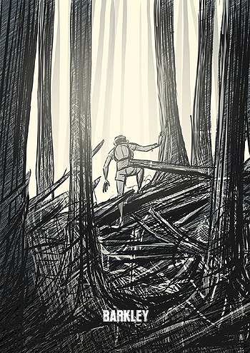
Photo Credit : Des Bosses et des bulles
Synopsis
I am honored and lucky to have been given another opportunity to participate in the one and only Barkley Marathons. Past events have been quiet, introspective, and “dark” challenges for me in some ways. In contrast, 2016 was a different experience as I traveled out with other people, had multiple close friends running, Mindy (my wife) came along, I had fantastic company for the first 4 loops, the skies were clear for nearly the entire race, and the temperatures were perfect. Was this really Barkley? I am thrilled to have finished in 59 hrs 33 minutes, forfeiting only 27 minutes and setting a new personal standard for how much adventure I can extract out of $1.60.
Posted by: runuphill | February 11, 2016
Running Up For Air – 2016
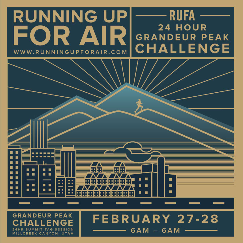
RUFA 2016 – We’re on! Details here.
Posted in Uncategorized
Posted by: runuphill | September 12, 2015
WURL – Sep 7th 2015
I have wanting to give the WURL a solid effort for many years. I personally feel that it is one of the most inspiring lines in the Wasatch Mountains. It is clean and non-contrived. Clean in the sense that once the ridge is acquired you simply stay on the ridge for the next ~25 miles never needing to leave the crest by more than 30 feet or so. It is humbling, beautiful, and precisely where I wanted to be on this incredible September day.
My 2015 adventure agenda has turned out to be quite different than originally planned. With several big objectives foiled by 1) an odd recurring respiratory issue and 2) the intense dump of snow in the high-country in June, I’ve had to shift gears a bit from my typical uber planned-out mode into a more ad-lib style. Thankfully the stars aligned to give the WURL a go. This time around I would have folks meet me with food and water rather than making caches. Ben/Bethany/Aida met me at Cardiff Pass, Mindy/Phoebe at the top of the Tram, and Ryan McDermott just below the Pfeifferhorn.
I started at 3:01AM. The quiet march up Ferguson Canyon is a nice time to calibrate for what lies ahead. Given the time of year, the few locals who do head up this canyon had done some much appreciated pruning, resulting in a trail was much easier to follow and not over-grown. Thanks! The quartzite ridge up to Broads Fork Twin Peaks is arguably my favorite part of the entire traverse. I moved through Sunrise and Dromedary efficiently and was then greeted with the most beautiful sunrise as I boulder-hopped my way along the Wasatch Ridge en-route to Monte Cristo.
Posted in Scrambling
Posted by: runuphill | August 23, 2015
Wasatch Ultimate Ridge Linkup (WURL)
WARNING : The WURL is NOT a trail. Rather, it should be thought of as an endurance scrambling route that happens to have trails in brief sections. To safely tackle the route you should have a solid background in rock climbing and extensive experience travelling over very loose and rocky terrain. There have been serious accidents and deaths on the peaks and ridges included in the WURL. Educate yourself on the risks, take the time to build your competency, and ensure that you are prepared before attempting. Just as with any climbing or hiking guidebook, this page is maintained in an effort to enable a safer and more informed experience.
The Wasatch Ultimate Ridge Linkup or “WURL” is an incredible ridge route circumnavigating Little Cottonwood Canyon in the Wasatch Mountains of Utah. The route mainly consists of scrambling, boulder hopping, and a few rugged trails. It is ~36 miles long with ~18kft of elevation gain. Given the recent increase in interest with the route, I’ve created this page in an effort to provide better information about it as well as document successful efforts, worthy attempts, interesting related information, and Fastest-Known-Times (FKTs).
If you are interested in being listed on this page, please leave a comment below with :
- Your full name(s),
- Day and time of completion,
- Elapsed time
- Link to some form of verification (preferably online GPS data).
A re-cap or link to a more in-depth “race report” is also highly recommended. If I have somehow missed your past finish, please leave details so I can correct it.
Posted in Uncategorized
Posted by: runuphill | August 10, 2015
John Muir Trail

Forester Pass – JMT 8/11/2015
Aftermath
Short Version
- We bailed via the Taboose Pass exit and ultimately made it out okay
- Medical issues : I contracted a chest cold in the days prior to our departure which I wasn’t too concerned about. From the beginning, however, all systems were not go. I figured I’d give it a good 24 hours to see if it would turn around. Sadly, my condition worsened to a state where pushing further on such a committing route would not have been safe. Symptom’s : nasty cough w/ lung material coming up, head-ache, and multiple (increasing in temperature) fevers.
- Ty was having a different set of challenges for the day so both of knew that an exit was the right call.
- Yes, we’re bummed, but as Ty says, “there’s no such thing as a bad day in the mountains.”
- We had a pretty awesome “reverse Badwater-esque” exit out to highway 395 from Taboose Canyon. If my fever weren’t enough, the conditions during our exit sealed the deal for some excellent Badwater training (i.e. marching into a fiery furnace)
- I’m reminded, yet again, how much I appreciate my great friend Ty Draney
- I’m also reminded, yet again, of how fortunate I am to be able to explore such beautiful and wild places
Long(er) Version
- Coming
It’s finally here! Tomorrow (8/11/2015) morning Ty Draney and I will embark on the John Muir Trail. Below are several resources to track and gauge our progress:
- Online CalTopo map of the route with milestones identified
- Time-table with distances and our initial time estimates
- SPOT GPS tracker
We’re going south to north and unsupported. We’ll have the SPOT in “track” mode so it should send an update every ~10 min.
Posted in Uncategorized
Posted by: runuphill | January 30, 2015
Running Up For Air (RUFA) 2015

Above the pollution looking south from the summit of Grandeur Peak.
At 6AM on February 28th, 2015 I intend to begin another 24 hour challenge on the west side of Grandeur Peak. I encourage anyone to come join me for what is guaranteed to be a memorable day. Your quads will remind you of it for days (if not weeks)! This is not a race, nor is it an organized event in any fashion. Come and go as you please. Obviously come prepared to take care of yourself just as you would on any other day in the mountains. The Route I’ll be following the route as shown on the Salt Lake County map located at the west side trailhead, which can be found here. Shelter Bob Palais has graciously offered to open his doors to those who come to participate. And, his house could not possibly be in a more ideal location, less than 100 feet from than trail! We’ll have a large pot of soup and basic hot drinks in his garage. If you ask nicely, I’m sure he’d let you store a “drop-bag” there filled with whatever clothing, food, and equipment you decide you need. Food contributions will gladly be set out for other runners/hikers to enjoy. See the map below (red line) to find Bob’s house. Parking So as to not overwhelm the tiny parking lot at the trail-head, I strongly suggest that you park at Eastwood Elementary and walk the 0.5 miles to the trailhead or Bob’s house to drop off anything.

Trailhead and Parking (suggested)

Pollution buildup over just a 5 hr window.
Results:
A respiratory infection sadly meant that I wouldn’t be running the event myself. Rather, I ended up serving food and drinks for all the wonderful folks who came out.
| Name | Summits |
|---|---|
| Luke Nelson | 6 |
| Ty Draney | 5 |
| Kyle Markesitch | 4 |
| Austin Madsen | 4 |
| Erik Storheim | 4 |
| Nate Pack | 2 |
| Brian Peterson | 3 |
| Jeff Brown | 3 |
| Ben Lewis | 3 |
| Doug Oliver | 3 |
| Roch Horton | 3 |
| Tetsuro Ogata | 3 |
| Dale Heisler | 3 |
| Jason Eichorst | 3 |
| Ryan McDermott | 3 |
| Abby Rideout | 3 |
| Vinze Clortho | 2 |
| Jack Carrick | 2 |
| Josh Alread | 2 |
| Drew Lewis | 2 |
| Shannon Wells | 2 |
| Mike Kampian | 1 |
| Andrea Kampian | 1 |
| Laney Markesitch | 1 |
| Thomi Liebich | 1 |
| Keith Sanders | 1 |
| Joel Pierson | 1 |
| Julia Pierson | 1 |
| Zoe Adler | 1 |
| Mindy Campbell | 1 |
| Bob Palais | 1 |
| Bethany Lewis | 1 |
| Josh Bradrofd | 1 |
| Tyler Lamprecht | 1 |
| Bart Hamatake | 1 |
| Krista | 1 |
| Liz | 1 |
| Anatoliy Zharkikh | 1 |
| Dave Ellis | 0.9 |
| Teresa Hicks | 0.7 |
| Charlie Caughlin | 0.8 |
| Steve Rideout | 0.2 |

Posted in Running
Posted by: runuphill | January 2, 2015
2014 – ReCap of the Best Year Ever
If being new parents wasn’t enough to make this the most memorable year of our lives, we threw in a handful of superb adventures, races, and trips to easily secure 2014 year the title of BEST YEAR EVER. Below are some of the highlights:
January
- Pretty clear focus on learning how to raise a newborn. Mindy proves, yet again, how broad her amazingness is with her seamless adaptation to the role of mother. Truly incredible, it’s an honor to be along for the ride.
- Phoebe summits Grandeur at 4 weeks old.

Our Campbell family on Grandeur Peak.
Posted in Yearly Recap
Posted by: runuphill | August 22, 2014
Idaho 12ers

Luke and Jared on the summit of Mount Breitenbach.
This write-up is meant to be supplemental to the very thorough post by Luke Nelson.
Short version : On August 16th and 17th, 2014, Luke Nelson and I ran, climbed, and crawled our way to the summits of the nine 12,000’+ peaks in Idaho in a time of 28 hrs 18 min.
Long version:
Oftentimes big adventures are more about who you’re with than what you’re actually trying to accomplish. When Luke asked me to be part of his Idaho 12ers FKT assault I immediately said yes, partly because it sounded like a cool adventure, but more just because I wanted to get to know Luke better. We were due to tackle something big together.
The objective is obscure, which added to the allure. Off the radar of most trail runners because of the sketchy terrain and logistics involved, and off the radar of most climbers because of the rotten rock and length of time required. Fortunately, Luke and I have climbing in our roots and have both spent inordinate amounts of time shuffling around the mountains. Thus, we seemed well-suited for such an adventure. By the numbers, the record seemed well within reach barring any major errors. Our daily lives prevented us from getting out for much recon, other than an ascent of Hyndman, which I snuck in the day after my wife ran the Standhope 60km the prior weekend. This meant that much of our planning would be via maps, Google Earth, beta from several key locals, and scoping the route while we drove up Highway 93…. This lack of more optimal preparation added a fun element of improbability, stacking the odds against us to some extent.

Lost River Range as seen from Highway 93 on the western side of the Lost River Range.

Scoping the Lost River Range with binoculars and an iPhone camera… We would refer to these images during the LRR traverse
Posted in Running, Scrambling
